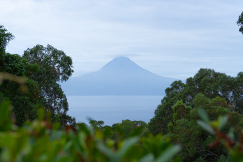
The Portuguese island of Madeira, located in the Atlantic Ocean near the coast of Morocco, is in my opinion one of the most interesting destinations in Europe. The island is mountainous, of volcanic origin and has a tropical climate. The greatest tourist attractions of Madeira are its hiking trails, where you can enjoy beautiful views of the mountains, the coastline and the waters of the Atlantic, all surrounded by lush green, tropical nature. Some of the routes lead along the irrigation channels – levadas. Actually, there is something for everyone. You can go for a simple walk or try a real hike, which will be quite a challenge but at the same time will guarantee the most spectacular views. I have created a list of all the best hikes and levada walks in Madeira, along with practical tips. Enjoy!
Vereda do Pico do Areeiro – PR 1
The Vereda do Areeiro trail connects the two highest peaks of Madeira – Pico do Arieiro (1817 m) and Pico Ruivo (1861 m). It is considered the most beautiful trail on the island. By climbing these peaks you can find yourself above the clouds and the views during the hike are breathtaking. The trail includes tunnels carved in volcanic tufa, steep climbs and descents. Among the most interesting places of interest is the Ninho da Manta lookout point overlooking the Fajã da Nogueira Valley, São Roque do Faial and much of the Central Massif. The most difficult part of this trail is the climbing of Pico Ruivo. The trail leads through the Natura 2000 area. This is also the best place to see the sunrise in Madeira: Pico do Arieiro – the most beautiful place for a sunrise on Madeira
Characteristics:
Access: 5.6 km
Return: 7 km
Duration: 3 hours – 3 hours 30 minutes
highest point: 1861 m above sea level.
lowest point: 1542 m above sea level.
Start: Miradouro Pico do Areeiro
End: Pico Ruivo
Bus: no
Difficulty level: medium/difficult
Vereda do Pico Ruivo – PR 1.2
The route enables you to reach the highest peak in Madeira – Pico Ruivo (1861 m above sea level). Following this trail, you climb along the mountain ridge separating the Faial and Santana cliffs. There are several huts along the route, which are useful in case the weather breaks down, which is normal in Madeira. The trail is part of the Natura 2000 area, with bushy vegetation along it, well adapted to temperature fluctuations, heavy rain and strong winds. From the trail you have a view of the Ribeira Seca Valley with the peaks of Pico das Torres and Pico Areeiro and the Ribeira Grande Valley with the volcanoes Caldeirão Verde and Caldeirão do Inferno.
Characteristics:
Distance: 5,6 km
duration: 1 hour 30 minutes
Highest point: 1861 m above sea level.
Lowest point: 1535 m above sea level.
Beginning and end: Achada do Teixeira
Bus: no
Difficulty level: easy
Levada das 25 fontes – PR 6 and Levada do Risco – PR 6.1
These are two trails with a the same beginning that lead to spectacular waterfalls. They are separated and run along two parallel levads on different levels. The PR 6.1 trail leads along the Levada do Risco at 1000 m above the sea level to the impressive Risco Falls. On the PR6 trail, you can visit the Lagoa das 25 Fontes waterfall, which is made up of waters flowing down from Paul da Serra. There is a legend associated with this place that none of the daredevils diving here has ever surfaced. The same thing supposedly happened to an Englishman who wanted to break the curse and… disappeared forever. So maybe you shouldn’t push yourself there for a dive on purpose ;).
Characteristics:
Distance: 9.2 km
Duration: 3 hours.
Highest point: 1290 m above sea level.
Lowest point: 900 m above sea level.
Start and the end: E.R.110 (Rabaçal, Paul da Serra)
Bus: no
Difficulty level: average
Levada do Alecrim – PR 6.2
Levada to Alecrim trail has its beginning and end in Rabaçal. It is also called the Lake of Madeira route. During the three-kilometers walk you can see beautiful views of the Rabaçal valley. Lush vegetation makes the walk more pleasant and you can also meet many animals, especially many species of birds. The trail leads between waterfalls and lakes. The most beautiful lakes are Lagoa D. Beja and Lagoa to Vento. Very popular among tourists is swimming in one of them. Levada do Alecrim is an easy trail to take with children.
Characteristics:
Distance: 6 km
Duration: 2 hours.
Highest point: 1355 m above sea level.
Lowest point: 1290 m above sea level.
Start and the end: Rabaçal
Bus: no
Difficulty level: easy
Vereda da Lagoa do Vento – PR 6.3
The trail starts near Rabaçal and leads through a small part of Levada to Alecrim and Lagoa to Vento. It’s a really beautiful route, and the waterfall adds variety to it. A perfect hike for all those who want to discover the new places and admire nature. The trail leads to the top of Risco Falls and there are several viewpoints along the way. It’s more difficult and there’s a lot of humidity, so it can be slippery.
Characteristics:
Distance: 6.7 km
Duration: 3-4 hours.
Highest point: 1289 m above sea level.
Lowest point: 1042 m above sea level.
Start and the end: Rabaçal
Bus: no
Difficulty level: difficult
Vereda da Ponta de São Lourenço – PR 8
The trail leads through a long, narrow peninsula at the eastern end of Madeira. Here you can admire the best cliffy scenery on the island. The trail reaches Cape Sao Lourenço, the eastern point of the island. It is not difficult, but quite undulating. The climate here is semi-desert, you can come across many endemic plant species, several species of birds, the Madeira lizard – the only reptile on the island, several endemic species of snails, and the rarest seals in the world – Sea Wolves. At the end of the trail, you can dive in the port of Sardinha.
Characteristics:
Distance : 8 km
Duration: 2 hours 30 minutes
Highest point: 110 m above sea level.
Lowest point: 5 m above sea level.
Beginning and end: E.R. 109 (Baía d’Abra – Caniçal)
Bus: SAM: 113
Difficulty level: average
Levada do Caldeirão Verde – PR 9
The Levada, which was built in the 18th century, begins in the Queimadas Forest Park, in the main stream channel of the Verde Caldeirão stream. It passes through steep cliffs and mountains, so that water flows from the highest peaks of Madeira. It is used for agricultural purposes. The most interesting places are the deep valley of São Jorge and hand-carved rock tunnels. In addition to the natural beauty of the trail, you can visit the small village of Achada do Marques, where there are traditional agricultural terraces and old stone huts. You will aslo find here Caldeirão Verde waterfall.Read more about this amazing place here: Magical tropical Madeira – the Caldeirão Verde waterfall
Characteristics:
Distance: 13 km
Duration: 5 hours 30 minutes
Highest point: 980 m above sea level,
Lowest point: 890 m above sea level,
Beginning and the end: Parque Florestal das Queimadas
Bus: Horários to Funchal 56, 103, 138
Difficulty level: easy
Levada do Furado – PR 10
The trail leads between Ribeiro Frio and Portela. The landscape here is dominated by the beautiful Ribeiro Frio Valley. There are also fields of Faial, São Roque do Faial and Porto da Cruz. The most impressive thing is the rock formation of Penha de Aguia, which forms a bay, separating the east of Faial and west of Ponta dos Clérigos. Along the route there are forests with endemic species, the firecrest – the smallest bird in Madeira and the Madeira pigeon.
Characteristics:
Distance: 11 km
Duration: 4-5 hours.
Highest point: 870 m above sea level.
Lowest point: 520 m a.s.l.
Start: E.R. 303 (Ribeiro Frio)
End: E.R. 102 (Portela)
Bus: Horários to Funchal 56, 103, 138 and SAM 20, 53
Level of difficulty: average
Vereda dos Balcões – PR 11
The short trail Vereda dos Balcões starts in the mountain village of Ribeiro Frio and leads to the levada Serra to Faial. From the Balcões lookout point there is a wonderful view of the green valley of Ribeiro da Metade, which is overgrown with Laurisilva forests. On very sunny days with good visibility you can also see the Central Mountain Chain and the highest peaks of the island: Pico Areeiro (1817 m), Pico do Gato, Pico das Torres and Pico Ruivo (1861 m). A great attraction of the trail, especially for geotourism lovers, are the exposed geological layers of the rock formations of Penha d’Águia. The area is part of the Natura 2000 area.
Characteristics:
Distance: 3 km
Duration: 1 hour 30 minutes
Highest point: 630 m above sea level.
Lowest point: 630 m above sea level.
Start and end: E.R. 103 (Ribeiro Frio)
Bus: Horários to Funchal 56, 103, 138
Difficulty level: easy
Vereda do Fanal – PR 13
The trail starts on the Paul da Serra plateau and ends in Fanal, near the forest watchtower. There is also a volcano crater on the top. From there you can enjoy spectacular views of the island and the ocean. The trail is located in the area of the Laurissilva forest, which has been classified as a UNESCO World Natural Heritage Site, and is also a member of Natura 2000.
Characteristics:
Distance: 10.8 km
Duration: 4 hours.
Highest point: 1420 m above sea level.
Lowest point: 1130 m above sea level.
Start: E.R. 209 Assobiadores
End: E.R 209 Fanal
Bus: no
Difficulty level: average
Levada dos Cedros – PR 14
Levada begins on the Paul da Serra plateau, the only plateau in Madeira. Levada dos Cedros is a 17th century water channel. The route leads through the Laurissilva forest and the Fanal crater. The most interesting thing are Laurel forests that remember the times before the discovery of the island. The water in the levada comes from the Lombo do Cedro springs, located at the altitude of 1000 m above sea level.
Characteristics:
Distance: 5.8 km
Duration: 3 hours.
Highest point: 1130 m above sea level.
Lowest point: 840 m above sea level
Start: E.R 209 (Fanal)
End: E.R 209 (Curral Falso)
Bus: no
Difficulty level: easy
Levada do Rei – PR 18
The route passes through the northern part of Madeira, starts in Quebradas and ends at the Bonito Ribeiro stream, which is the source of the levada. The beginning oth this trail route leads through a forest area, but after that you can enjoy the beautiful views of São Jorge and the fields of Santana. Since there are tunnels along the route, remember to take a torch. The water of the lavada feeds the historic water mill in São Jorge, which has been in operation continuously for 300 years.
Characteristics:
Distance (access and return): 10.2 km
Duration: 3-3 hours 30 minutes
Highest point: 710 m above sea level.
Lowest point: 530 m above sea level.
Beginning and the end: ETAR de São Jorge
Bus: Horários to Funchal 103, 138
Difficulty level: easy
Levada dos Tornos – Boaventura
The trail starts in the area of Lombo to Urzal (Boaventura) from where it leads up to the left, to the beginning of dos Tornos stream, near a beautiful waterfall. The levada itself passes through a large part of Madeira, bringing water from north to south. The hike leads among lush vegetation. Several endemic plant and animal species can be observed on the trail.
Characteristics:
Distance: 12.9 km
Duration: 4-6 hours.
Highest point: 679 m above sea level.
Lowest point: 399 m a.s.l.
Start: Lombo to Urzal
End: Fajã do Penedo
Bus: no
Difficulty level: average
Levada da Ribeira da Janela
The trail of levada da Ribeira da Jenela has 26 km long. Therefore, it is a difficult route, not for everyone. There are nine tunnels, the longest of which is almost 2 km long. The hike starts in Porto Moniz and leads through the first 13 km to the interior of the Ribeira da Janela Valley. Its end is Ribeira da Janela. There is a beautiful view from here, dominated by monumental rocks. Among the rocks, crystal clear water flows, creating small ponds that are deep enough to swim in.
Characteristics:
Distance: 26.8 km
Duration: 5-8 hours.
Highest point: 424 m above sea level.
Lowest point: 407 m a.s.l.
Beginning and end: Porto Moniz
Bus: Rodoeste 80, 139, 150
Difficulty level: difficult
The photos you can see in this post are the effect of my collaboration with Michael. We believe in the synergy effect, which is why we have decided to work together during this trip. We hope that it will be an inspiration for your European trips.
If you like me post and find it helpful I would appreciate if you buy me a coffee and support my work. Thank you so much! :)
Welcome on my blog about traveling, active lifestyle and chasing all the crazy dreams. I have been on 6 continents and in more than 100 countries so far, but I still have so much to explore :)
Welcome on my blog about traveling, active lifestyle and chasing all the crazy dreams. I have been on 6 continents and in more than 100 countries so far, but I still have so much to explore :)