Hike to Bärenkopf around Lake Achensee in Tirol, Austria
The Achensee region in Austria has more than 500 kilometers of well maintained and marked hiking trails. There are plenty of choices. From easy, flat trails, such as the Karwendel valleys from Pertisau, to difficult hikes and summits. The Rofan cable car and the Karwendel cable car allow you to cover the first few kilometers and shorten the march by a few hours if necessary. I particularly recommend the classic hike around Lake Achensee, which guarantees beautiful panoramic views on the way.
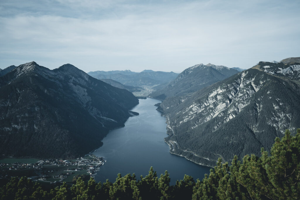
The peaks around Achensee are the most popular hiking destinations in the Karwendel and Rofan mountains. One of the most spectacular is the Bärenkopf – a rugged mountain landscape with rare rocky vegetation and mountain pine fields in the south-eastern Karwendel mountains. The Treck on the Bärenkopf is one of the most important attractions in the region, as it offers the view of the valley and the intense blue lake Achensee. Bärenkopf was rightly recognized in 1989 as an area of particularly beautiful nature (and is also part of the Karwendel Nature Park). The area is protected in order to preserve the unique landscape and its recreational value.
My experience with hiketoBärenkopf
Our journey to Bärenkopf started in Pertisau. At first, we took the Karwendel cable car to the 1500m high Zwölferkopf.
From Baerenbad Alm pasture you can reach the summit in around 1.5 hours, but if you want to cross the Weissenbachsattel, the route takes around 2 hours.
The first section of the trail, which is short, leads downhill and then climbs up to the Bärenbad Alm hut. It is a popular destination for hikers and mountain bikers who fall into the Kaiserschmarrn (sweet, fluffy pie). It’s a pleasant place to stop with a view of the beautiful mountain landscape. We missed it, because we walked in the morning and it was still closed.
From the shelter a more difficult part of the trail begins, up the narrow and slightly slippery route (slippery stones). In the most difficult places, the route is secured with steel ropes.
A panoramic view of the blue lake Achensee, bordering on the untouched Karwendel mountain range and the rocky Brandenberg Alps, awaits up hill.
When the weather is good, it’s such a nice place to have a picnic on one of the meadows surrounding the summit (in my opinion this is a lot better than a break in a hut). Let’s agree that coffee with a view of the Alps tastes best in the world!
Uwielbiasz podróże?
Chcesz zacząć zarabiać na swojej pasji do podróżowania i przekuć ją w życie i pracę marzeń?
Biblia Blogera i twórcy online to największe kompendium wiedzy na polskim rynku, które konkretnie i bez owijania w bawełnę pokaże Ci, jak krok po kroku sprawić, abyś podróżował po całym świecie i żeby jeszcze Ci za to płacili. Znajdziesz w niej moje sześcioletnie know-how i wszystkie strategie, dzięki którym zbudowałam markę Travel and Keep Fit i stworzyłam wokół podróży milionowy biznes.
As far as the entrance was pleasant, the descent was not so much. We have been a little lost and didn’t check what time the last cable car goes down. Of course, it turned out that we had about 40 minutes to catch it. It’s been a long time since I ran down so fast (I don’t recommend it, because it is extremely slippery). Unfortunately, we didn’t make it to the cable car station on time, but luckily, we were picked up by the shelter’s employees, who were just coming home. Call it luck!
Unlike us, you can choose a slightly longer, but easier trail. The first section to the rocks is the same as at the entrance. However, at the crossroads you have to choose the road to the Weißenbach Alm. The trail takes you through meadows and forests and through Weißenbach Pass and back to Bärenbad Alm, from where you can take the Karwendel cable car downhill.
Whether you choose to take the route through the forests of Tilio-Acerion, the Weißenbachtal or the route from Zwölferkopf via Bärenbadalm, you will be delighted by the variety of flora and fauna around Bärenkopf. Many of the plants that grow here are protected. There is so much to discover: Between the Weißenbachalm valley and the peak, there is a heathland, and in the top part of the Bärenkopf you can admire impressive rock formations. Depending on the starting point, the hike to the peak takes 4 to 6.5 hours.
The most important information about the route:
Starting point: Pertisau, Karwendel cable car (Zwölferkopf)
Distance: 2.9 km (direct road to the top, in each direction), 7.4 km (round trip)
Walking time: about 4 hours (whole circular trail)
Height difference: approx. 660 m
Altitude: between 1450 and 1990 m above the sea level.
The photos you can see in this post are the effect of my collaboration with Michael. We believe in the synergy effect, which is why we have decided to work together during this trip. We hope that it will be an inspiration for your European trips.
If you like me post and find it helpful I would appreciate if you buy me a coffee and support my work. Thank you so much! :)
Welcome on my blog about traveling, active lifestyle and chasing all the crazy dreams. I have been on 6 continents and in more than 100 countries so far, but I still have so much to explore :)
Welcome on my blog about traveling, active lifestyle and chasing all the crazy dreams. I have been on 6 continents and in more than 100 countries so far, but I still have so much to explore :)