Have you ever experienced such paradox: the less you expect from the place you’re visiting, the more it seems to prove how wrong you were?
During this trip to Switzerland I had a precise list of places I wanted to visit and on the top of it were those routes, which in my opinion are in the top league of the most spectacular mountain trails.

And the most important of them was, above all, the Augstmatthorn trail (because I’ve seen so impressive shots in the Internet that it kept haunting me in my dreams). 5 Lakes Trail in Zermatt was kind of an addition, something that appeared on the list much later and definitely not as awaited as the king of the list. The morning was very rainy and it was windy as hell, so I was very close to call it off.
Only till the moment when I stepped into the funicular car and through the windows I saw a breathtaking view. The clouds dispersed like enchanted by some kind of a kind magician.
I walked only 100 meters and I already got stuck on the trail for 40 minutes… because I just couldn’t hold myself from taking picture after picture.


Later it kept getting “worse” – I was hiking endlessly and instead of planned 3 hours I stayed there for 8. Everything enraptured me and overwhelmed me with its majesty, almost literally taking my breath away sometimes. I learnt another valuable lesson – don’t expect and you shall receive. In my opinion it was the most beautiful hiking during my trip.
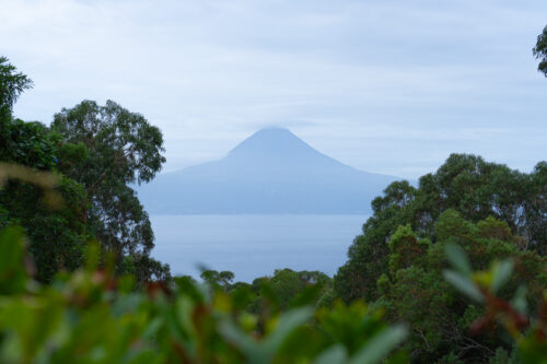
The 5 Lakes Hike, known also as 5 Seenweg Hike, is one of the most popular trails in Zermatt. During this 9-kilometer long walkabout you not only admire 5 unique lakes but also the panorama of snow-capped mountains, incredible green and the one and only Matterhorn (the one you know from Toblerone chocolate packaging).

Before you decide to take this trail, you should take a look at all those practical advices, as they might prove useful while planning this excursion. We’ll begin with logistics and then cover also weather and the trail itself. I hope that this small guide would answer the questions that might arise during your preparations.
When to go on the 5 Lakes Hike
Because the trail begins at the level of 2600 meters above sea level, it is totally covered in snow during the whole winter and also partially during the spring. It becomes available for tourists only after it is cleared of snow, which can be delayed even till the beginning of May. I would suggest that before you come there, you should write an email to the touristic bureau of Zermatt and ask if the trail would be accessible in the period desired by you.


Another thing to think about while deciding when to hike is the weather. Of course, in the mountains the weather is unpredictable but because the main attraction of the hike are sights of the Matterhorn and the landscape, I’d say that you should wait for the day, in which ceaseless rain does not appear in the weather forecast. In order to check it, you can visit meteoblue.com website or check the Zermatt webcams before you head off towards the mountain.
However, even if the expected weather is not the dreamy and perfect one, I would still take up the gauntlet. I was there on a day, during which sunny moments were alternated with drizzle and clouds and in my opinion it was spectacular – diverse, mysterious, sometimes foggy, mixing into an awesome effect.
How to reach the starting point
The official starting point on this trail is Blauherd, at 2571 meters above sea level. In order to reach it, you should first take the underground funicular from Zermatt to Sunnegga and then another mountain lift from Sunegga to Blauherd.
But remember that sometimes one of these stages might be closed. You should absolutely check the timetable on the Zermatt website (scroll down to “mountain lifts schedule” and download the right timetable).
If it happened that the funicular from Zermatt to Sunnegga was closed, then you would have no other option than to go on foot from the Zermatt city to the Blauherd. It takes about 3 hours.
But if the Sunegga funicular is operational but the Blauherd chairlift is closed, then it’s a little bit easier, because walking from Sunegga to Blauherd lasts about 45 minutes uphill.

The map below shows all the main points on the way to Blauherd (including hiking from Sunnegga to Blauherd, if the chairlift is closed).
How much does it cost
You can purchase tickets for the cable car directly at the funicular station in Zermatt. You’d need one-way ticket to Blauherd and one return ticket from Sunnegga to Zermatt.
Combo Ticket: Zermatt – Blauherd; Sunnegga – Zermatt: CHF 39 (CHF 19.50 with Half Fare Card or Swiss Travel Pass).
If the Blauherd chairlift is closed: Zermatt to Sunnegga round trip: CHF 24 (CHF 12 with Half Fare Card or Swiss Travel Pass).
I recommend to also check the prices and pass options in the Train Travel in Switzerland Guide.
The 5 Lakes Hike
If you reached Blauherd, it’s just about the time to begin your hike around the 5 lakes. You’ll be guided by yellow signs – they indicate that you are on the right trail. Because in the area there are several tourist trails, it is important to follow the yellow signs of 5 Lakes Hike – some of the other trails lead to the other parts of these mountains. You can always use Google Maps to see where you are, compared to the whole trail and all the lakes.

The route itself is a combination of a gravel road and a real trail, so basically it’s for everyone and you don’t need to prepare especially for it. I would call it a pleasant walk.
The starting point: Blauherd – most of the trail leads downhill, there is only one, last stage going uphill. The overall altitude change during the hike covers 286 meters up and 575 meters down.
Lake no. 1: Stellisee
Lake no. 2: Grindjisee
Lake no. 3: Grunsee
Lake no. 4: Moosjisee
Lake no. 5: Leisee
The finish: Sunnegga
The trail begins with Stellisee, I guess the most famous of all the 5 lakes, thanks to a numerous mass of pictures in the Internet, showing a perfect reflection of mountains on the water surface. But for me the beginning was even more spectacular, thanks to absolutely unbelievable views on the surrounding Alps and the Matterhorn, slowly emerging from behind the clouds. I got stuck at the first stage, because I just couldn’t feast my eyes full on the beauty of the landscape. The lake itself is the biggest one on the trail, so it’s worth to spend a while and walk around it, to see everything from every possible perspective.


The next is the Grindjisee lake. On the way you’ll be passing by flocks of sheep and numerous small waterfalls, flowing out of the mountainsides. The pure essence of the Switzerland. However, the lake looks like a huge pond, surrounded by trees, bushes and tall grass. The path around it is a bit overgrown, so many don’t even try to walk it but if you do, you’ll be rewarded with the view of Matterhorn, looking at itself in the lake mirror.


The gravel road leads to the third lake, Grunsee. When I reached it, the weather changed again, it began to rain and the sky became overcast, giving the lake a mysterious, remarkable vibe. When the surface of the water became smooth, I was given a chance to see one of the most beautiful reflections I have ever seen. For me it was the prettiest sight of this hike.


Here, as a hiking interlude, I recommend dropping in to the Ze Seewjinu restaurant, the only one on the trail. It has a beautifully situated terrace, from which you would be able to admire the mountains, while sipping coffee and enjoying a sensational apple strudel with ice-cream. It would be a real shame not to experience this.


Then you’re off downhill from Grunsee to Moosjisee. You’ll see it from afar, because it has a unique, greenish color.
After reaching Moosjisee there is only one lake left – Leisee. Reaching it would be the first walk uphill on this trail. This is the only lake with any facilities – there is a playground and a beach, so you can jump into the water. I was there late, about 6 PM, so no one was around. Besides, I have the impression that with every lake there were less and less people, until I was alone on the trail. There was little light then, so I didn’t catch any reflections of the mountains on the water surface.


This is where 5 Lakes Trail ends. You’ve done a huge circle and you can go back to Zermatt by the funicular you came there. Attention! You should check when the last cable car sets off. I was too long on the trail (oh, those pictures!) so I was late. I was really lucky, because the last guy from the staff was just about to ride down with the trash… so I lucked upon a ride next to garbage cans. And it was really the luckiest moment of this day, because if not for the garbage ride, I would have to walk downhill for additional 3 hours in the night and my knees probably wouldn’t let me forget about this for quite some time. You’ve been warned! :)